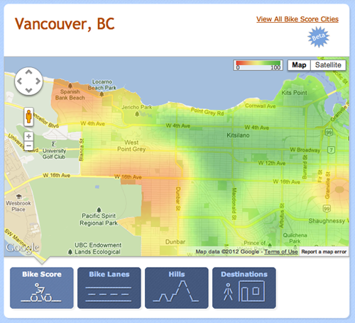
The media have been enraptured by the new UBC-research-powered site BikeScore, which creates a heat map of bikeable areas in cities and then ranks them in order of bikeability. Vancouver and Portland are among the most bikeable cities in North America! Hooray!
The Vancouver map is here—you can play around with it a little bit, with overall bikeability maps, hills, bike lanes and destinations where green is best and red is worst. Look at those verdant tracts of bikeability in West 4th! Isn’t Vancouver so sustainable, except for that bruised looking yellow and red patch? What is that, anyway? Oh right, every bike corridor leading to the university.
It doesn’t help that there are some tough hills leading up to the university on West 16th, West 10th, and West 4th. But the real danger is the lack of bike paths on 10th and 16th. (West 4th, which has a bike path, remains punishing because it’s such a longer, more winding route to the campus.)
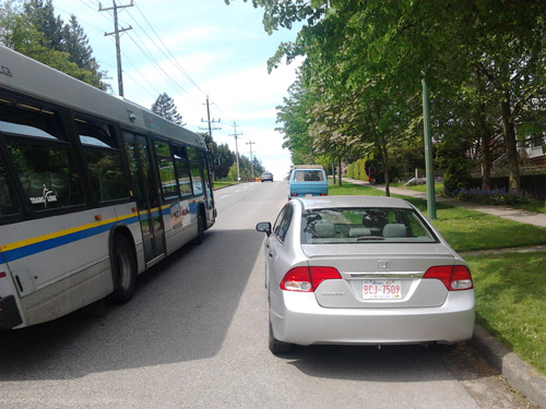
West 10th and 16th past Alma both send cyclists up challenging hills with no bike paths on particularly busy roads. The bikeway on West 8th is a nice alternative, but nobody knows about it. I’ve taken both routes, and especially in tough weather conditions, West 16th, an angry red blotch on the BikeScore map, can be a deathtrap as giant trucks rattle past cyclists squeezing through construction and cars parked on the side of the road. (See picture at the bottom of the post.) OpenFile’s Open Road cyclist accident map reports two accidents there between 2007 and 2011.
UBC itself isn’t too punishing for cyclists: although studies by the Vancouver Cycling Coalition aren’t going to be entirely happy about what’s going on there, they report that the problem is communication about infrastructure, not the lack of infrastructure. Both West 10th and West 16th pick up bike paths as soon as they enter the gentle embrace of Papa Toope, making this a Fucking Governance issue.
Even though UBC and Vancouver want people to know they’re working hard to be bike friendly, the path between the two isn’t that bikeable.
UPDATE: Campus and Community Planning sends along some usage statistics from 2011: Only 9% of incoming bike traffic comes from West 4th, which may be due to its generally punishing route. 50% enters via University Boulevard, showing that the 2011 decision to convert to bike lanes was fruitful—only 21% of traffic comes from West 16th, the route that draws much of my ire. The remainder flows through NW Marine Drive from the UEL and SW Marine Drive.


